


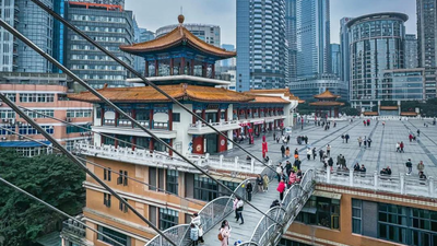
A tourist walks out of a shopping mall in Chongqing and onto a seemingly ordinary street. Cars pass by. Pedestrians move through the crowd. Restaurants and convenience stores line the sidewalks. Everything feels like it should. Then came the surprise. Leaning over a nearby railing reveals a dizzying drop that leads to another path below. What appears to be a street at ground level is actually dozens of meters above the city below. For many first-time visitors, this disorienting moment is their introduction to Chongqing, the sprawling Chinese metropolis that has earned an unusual nickname online: “8D Magic City.”
The geography behind China’s “8D Magic City”
Videos from Chongqing have become popular content on social media. Some photos show trains disappearing into apartment buildings. Others capture the maze of elevated roads that wind between skyscrapers. Several photos depict confused tourists trying to figure out whether they need to go up, down or through to reach a destination that appears to be within easy reach.The confusion is understandable.In most cities, people navigate using relatively simple mental maps. Streets intersect on a plane. Buildings rise from the same ground. Direction is measured in two dimensions. Chongqing has largely ignored these expectations.Here, a building might have entrances on several different floors, each connected to a different street. One pedestrian can exit the mall and emerge onto what appears to be the ground floor, while another enters the same structure from a path many levels below. Addresses mean something to locals. Visitors often need time to adjust.The city’s reputation as an “8D” landscape has less to do with technology than with perception. The topography creates an urban environment that is almost incomprehensible at first glance.
one Megacity Landscape shaping
To understand Chongqing, you need to see through concrete and glass.The city is located at the confluence of the Yangtze River and Jialing River in southwest China. Unlike many of the world’s largest urban centers, it is not built on a vast plain. Instead, it occupies a rugged landscape of steep hills, ridges, and valleys.Over centuries, settlements adapted to these natural contours. As Chongqing grows into one of China’s largest metropolitan areas, engineers and planners face a challenge rarely faced by cities like Beijing or Shanghai: How to accommodate millions of people amid a shortage of flat land?The answer is to build with the landscape rather than erase it.The road climbs the hillside. Bridges connecting different areas. Tunnels pass through mountains. Residential buildings rise from slopes that would otherwise be considered impractical. Over time, the city has developed as much vertically as it has horizontally.It turns out that elevation is almost as important as distance.
The train that caused an internet sensation
No icon embodies Chongqing’s unique personality better than Liziba Station.Images of the station often circulate online as the city’s monorail appears to run directly through the middle of a residential building. To someone seeing it for the first time, the scene looks like special effects from a science fiction movie.Reality is more practical.When transportation systems expand, engineers face severe space constraints. Rather than demolishing the existing structure or rerouting the line, they integrated the station into the building itself. Trains don’t go through people’s living rooms. Dedicated station floors occupy the space and noise reduction measures are built into the design.The solution reflects a broader pattern across Chongqing. Planners often find ways to adapt infrastructure to existing geography rather than forcing cities to adopt a traditional layout.This willingness to embrace unconventional solutions has resulted in some of the city’s most recognizable landmarks.Behind these viral videos lies a serious case study in urban planning.As the world’s population continues to migrate to cities, planners are increasingly looking for ways to accommodate growth rather than endlessly expanding into the surrounding countryside. Chongqing offers a glimpse into a possible future: intensive development across multiple vertical levels.The city demonstrates the opportunities and challenges of this approach.Efficient land use can support large populations while limiting outward spread. Transport systems can be integrated into steep terrain. Different levels of the city can serve different functions.However complexity comes at a cost. Navigation can be difficult. Infrastructure projects are expensive. Emergency plans, accessibility and transportation need to be constantly adapted.Many rapidly growing cities are likely to face these problems in the coming decades as available land becomes scarce and urban populations continue to increase.
Living in three dimensions
For residents, the novelty will eventually wear off.Roads that confuse tourists have become part of daily life. Elevators connecting different street levels are just another mode of transportation. The dramatic elevation change that inspired the viral video becomes the background scenery.Yet the city continues to grow. New developments, transportation projects and business districts are reshaping Chongqing while retaining its unique character.Its growth raises an interesting question. As the city’s population increases and technology allows for more ambitious construction, will other cities begin to follow Chongqing’s lead? Or is its unusual form a product of geography, making it difficult to replicate elsewhere?
A city that changes the way people see cities
Most cities teach their residents to think two-dimensionally. north or south. left or right. Near or far.Chongqing raised a third consideration. up or down.This simple difference changes the experience of moving around the city. A destination that appears to be just across the street may require several elevators, stairs and elevated walkways to reach. A street that feels fixed to the earth may actually be hovering high above another neighborhood.

